|
|
|
|
1. Project Partner
Joined for a Better Environment
- Puerto Rico Water Resources and Environmental Research Institute
- University of Puerto Rico at Mayagüez
- United States Geological Survey
2. Researchers

Walter Silva Araya, Ph.D.
PRWRERI Associate Director
University of Puerto Rico
Mayagüez Campus walter.silva2@upr.edu
3. Students

Keyshla J. Maldonado Rodríguez
Concentration: Agronomy and Topography
Undergraduate Student: Agronomy and Topography
Expected Graduation Date: May 2020
e-mail: keyshla.maldonado1@upr.edu

Francisco Rodríguez
Bachelor's Degree: Environmental Engineering
Master's Degree: Civil Engineering
Graduate Student: Civil Engineering
Graduation Date: July 2019
e-mail: francisco.rodriguez43@upr.edu

Xavier Babilonia
Concentration: Civil Engineering
Undergraduate Student: Civil Engineering
Expected Graduation Date: May 2020
e-mail: xavier.babilonia@upr.edu

Karlos F. Gongón Fuentes
Concentration: Civil Engineering
Undergraduate Student: Civil Engineering
Expected Graduation Date: May 2020
e-mail: karlos.gongon@upr.edu

Jon A. Rivera Matta
Concentration: Agronomy and Topography
Undergraduate Student: Agronomy and Topography
Expected Graduation Date: May 2020
e-mail: jon.rivera@upr.edu
|
|
|
|
|
Geomorphic evolution of the Río Grande de Añasco
Lower Valley and its impact on water resources
|
Duration: March 1, 2020 to December 31, 2021
Sponsoring Agency: United States Geological Survey (USGS)
Project Strategy, Technical Assistance
and Training Approaches
1. Project Narrative
Erosion and sedimentation is due to meander evolution in Río Grande de Añasco’s Lower Valley impact water resources.
The bank of material is easily removed by the river velocities promoting meander migration and erosion. Agricultural
zones are affected, and sediment deposition occurs downstream. The river’s morpho-dynamics change rapidly creating
oxbows. Contaminants move in sediment particles and discharge in the Mayagüez Bay, causing pollution in coastal areas
and affecting coral reefs. The river has a long history of meander migration and changes in horizontal alignment.
The water intake for the Miradero Water Treatment Plant is in an active meander migration zone. The treatment plant supplies water to more than 65,000 households from five municipalities. During hurricane María, the meander upstream of the water intake migrated to a position close to merging with the next downstream meander. If both meanders merged the river will not pass by the water treatment intake, leaving the water plant intake isolated from the river raw water supply.
This proposal will quantify meander migration in the lower valley of Río Grande de Añasco by using the International River Interface Cooperative (iRIC) state-of-the-art movable boundary models. Personnel from the USGS Geomorphology and Sediment Transport Laboratory (GSTL) will oversee training, including one day of field data collection. Existing and new field data will be collected and used for model preparation. Several scenarios will be modeled to determine meander evolution and impacts on infrastructure (treatment plant intake) and agriculture in the floodplain. The project will strengthen collaboration with USGS Research Hydrologists and provide a case-study for future studies in the flood-prone alluvial valleys in Puerto Rico and the Caribbean.
Statement of regional or State water problem
The Río Grande de Añasco is in the west-central part of Puerto Rico and is one of the most important rivers
discharging into Mayagüez Bay that drains one of the largest watersheds in the Island. The Añasco watershed
covers an area of 257 square miles and includes portions of Añasco, Mayagüez, Las Marías, Maricao, San Sebastián,
Lares, Yauco, and Adjuntas municipalities. The river headwaters are in the mountains of Lares. The lower valley
covers the watershed area between El Espino and the sea in Mayaguez Bay. The lower valley comprises a flat-lying
alluvial plain covering an area of approximately 16.4 square miles (10,500 acres). Nearly 6,000 acres are
dedicated to agriculture and the rest is either fallow or pasture [1]. Most of the land in the lower valley
is well-suited for mechanized agriculture [2]. About 85 % of the time the discharge at El Espino bridge exceeds
100 ft3/s and 50% of the time it exceeds 200 ft3/s. The average daily flow during the months of September to
November is greater than 120 ft3/s. Direct precipitation over the lower valley is a significant component of the
water budget in the region [3]. This represents the most important source of water for a variety of uses
in the west area of Puerto Rico. The present conditions of the Río Grande de Añasco Lower Valley exhibit the following problems:
Water Quality and Sediment loads
Besides the potential for food production, according to the Natural Resources Conservation Service (NRCS),
the watershed is ranked # 5 on the list of impaired watersheds in Puerto Rico’s Unified Watershed Assessment,
due primarily to sediment, bacterial, and chemical contamination (low dissolved oxygen, high arsenic, and turbidity).
Many of these pollutants are directly related to agricultural sources such as fertilizers, pesticides, and
manure from crop and pasture lands [2]. Sediment is the transport mechanism of several contaminants. Sediment
loads in the valley increase significantly during low-frequency events, discharging pollutants into the Mayag&uulm;ez Bay.
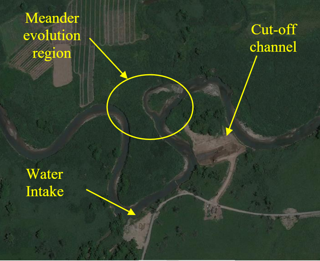
River intake and meander cut-off
The water intake for the Miradero Water Treatment Plant is in an active meander migration zone within the lower
valley of the Añasco River. The treatment plant supplies water to more than 65,000 households in five municipalities: Mayag&uulm;ez,
Añasco, Homigueros, Cabo Rojo and Rincõn. During Hurricane Marĩa the meander upstream of the water
intake migrated to a position close to merging with the next downstream meander. If both meanders would merge the river
will not pass by the water treatment plant’s intake, leaving the water plant intake isolated from the river raw water supply.
To avoid this critical situation, the Puerto Rico Water Authority (PRASA) approved the cut-off of the meander upstream of the water intake.
Figure 1 shows a picture during the meander cut-off works in May 2018. Before the meander cut-off, water flowed along 530 m around the meander.
After the cut-off, the distance reduced to 163m in a straight line. Now the water runs along a path 60% shorter, having a higher energy
level due to a reduction in friction and energy dissipation.
Consequently, the river currently has a higher energy gradient, increased velocity, and high bank and bottom erosion potential.
This condition typically will accelerate the creation of a new meander to reach equilibrium. Three possible consequences for this river conditions are:
-
The river will search for a new equilibrium, forming a new meander near the same location.
-
Bank and bed sediment will be carried out downstream producing aggradation and increasing the size of point bars.
- Sediment deposition near the water intake could impair the intake operation for water supply purposes.
Erosion and sediment transport are common concerns in all the described problems.
Figure 1: Meander cut-off under contruction. 5/1/2018 (Google Earth)
Statement of results and benefits
This project will bring the following benefits:
Quantitative analysis of sediment transport and meander evolution using state-of-the-art computer modelling. The project will create the first multi-dimensional morpho-dynamic model assembled for a river reach in Puerto Rico; using software developed by the USGS. The project will set the benchmark for similar studies in other alluvial rivers in Puerto Rico. Presently there are not quantitative fluvial hydraulic models for engineering design in Puerto Rico.
Field data collection will provide quantitative data for fluvial geomorphology models, particularly for the lower valley of the Añasco river.
The project will support hands-on training for a selected group of professionals and students in using USGS advanced multi-dimensional morpho-dynamic models (iRIC).
The project will strengthen collaboration between the University of Puerto Rico, the Water Resources and Environmental Research Center and the USGS.
The project will benefit farms near the river and PRASA by providing expected meander displacements and recommending design measures to protect crops and prevent hazardous conditions.
Could help PRASA in selecting alternatives and design measures to protect the integrity of the raw water intake and prevent critical situations affecting water supply to five municipalities.
Nature, Scope and Objectives of the project
Nature
The geomorphological characteristics of the rivers are in constant evolution. Sediment transport depends on the geologic composition of the area,
river characteristics, climatologic and hydrologic conditions. The interaction of those factors produces continuous changes visible during long
periods of time. The fluvial systems have major impacts on economic development. Large agricultural areas, mining, fishing, urban water supply
sources, urban/ industrial developments, and other economic activities related to natural resources occur within alluvial valleys that are
important components of river management [5]. Also, the fluvial system is the scenario of natural disasters such as floods, exacerbated bank
erosion, channel migration, and river aggradation or degradation. Geologic formations determine soil composition. Sedimentary and heavily
weathered rock formations are vulnerable to break into loose soil in a short period and contribute to the sediment transport process.
This process depends on layer compaction, grain size, the angle of repose, and the layer’s inclination of the formation.
Along the river stream, these layers are naturally exposed by the process of constant erosion. Water erosion is the action of a
surface flow or raindrops impacts which separates the soil particle. The particle may be moved from the point of origin into a stream
and transported downstream of the river or land surface [6]. The erosion process depends on the conditions of the soil surface, which
includes: geometry, slope, surface roughness, water depth, shear stress exerted by the water on the surface, and the maximum shear
stress that the layer formation can resist.
The capacity to transport sediments as bed material load or wash load increases when flow discharge increases. The increase of sediment transport depends on the hydrological characteristics and the existing geologic formation. Rain causes surface runoff which goes into a channel, increasing the water velocity and depth. This action increases erosion of the exposed surface and sediment transport toward the downstream river reaches. Under normal conditions, this process slowly changes channel alignment and shape, as well as, the floodplain landscape. The same changes occur at a much faster rate, in a short period of time, with low-frequency events such as hurricanes or tropical storms. Either way, the evolution of the geomorphology is more evident in alluvial valleys with non-cohesive soils. The alluvial material is a stratified deposit of gravel, sand, silt, clay, and other debris carried by the streamflow from a high altitude to lower ground elevations of the valley [7]. The climate conditions in the tropical regions impact the rate at which geomorphological changes occur, accelerating the evolution of the river processes [8]. Climate change in the tropics is expected to increase runoff and, consequently, aggravate floods and hazard conditions. Erosion can be accelerated or decelerated by human impacts, such as meander cut-off, which affects the equilibrium established by nature.
Previous research focused on protecting structures such as bridges and culverts from local scour, and regulations were available to control their impact over the river, however, much work needs to be done in the understanding of channel and floodplain evolution on a larger scale, both in time and space. The alluvial valleys in Puerto Rico are located near coastal areas and normally show a meandering pattern. The meanders are part of the constant evolution of the geomorphology of these zones. Oxbow lakes and dry channels are visible by examining aerial photos. However, quantitative research and numerical modelling on the prediction of geomorphological changes of floodplain in rivers in tropical islands are scarce and, in Puerto Rico it is non-existent.
The lack of historical data and field measurements limits the estimation of changes in river morphology during the useful life of major hydraulic structures or planning land development covering the range between 25 and 100 years. The use of state-of-the-art movable boundary hydraulic models combined with precise topographic data and geographic information systems, supplemented with field recognizance presents an alternative for the development of possible scenarios on the future behaviour of streams.
Scope
The proposal will quantify meander migration in the lower valley of Río Grande de Añsco. Qualitative flood plain evolution using photogrammetry and aerial photos is presently on-going [4], however, no quantitative data of meander movements have been developed. This research will supplement previous efforts. Data collection and documentation of river characteristics include planform, cross-sections, longitudinal profiles, and sediment data. Data collected will be input into a morpho-dynamic multidimensional model available as part of the International River Interface Cooperative (iRIC) platform developed by the USGS in cooperation with Hokkaido University in Japan. The simulation will include a river reach between El Espino and State Highway 22. Training in modelling meander evolution and field data collection for model input will be provided by the USGS (Geomorphology and Sediment Transport Laboratory (GSTL) in Golden, Colorado). Support from the Coastal Resilience Center (CRC) at UPR-Mayaguez will supplement the project efforts.
Objectives
The project objective is to study meander migration in the lower valley of the Añasco river by using field data and state-of-the-art movable boundary models capable of simulating meander evolution. The model iRIC (International River Interface Cooperative) developed by Professor Yasuyuki Shimizu (Hokkaido University) and Dr. Jonathan Nelson (USGS) will be used [9] for prediction of erosion, sediment discharge, and meander migration. Dr. Jonathan Nelson is a USGS Research Hydrologist and Chief of the Environmental Fluid Dynamics Project working at the Geomorphology and Sediment Transport Laboratory (GSTL) in Golden, Colorado. Dr. Nelson and two other trainers from the USGS will conduct a four-day workshop on morpho-dynamic modelling including a one-day field trip to the Añasco River for training on field data collection. Several scenarios will be tested to determine meander evolution, its impact on infrastructure (treatment plant intake) and agriculture in the floodplain. The project will provide a case-study for future studies in the flood-prone alluvial valleys of Puerto Rico and the Caribbean.
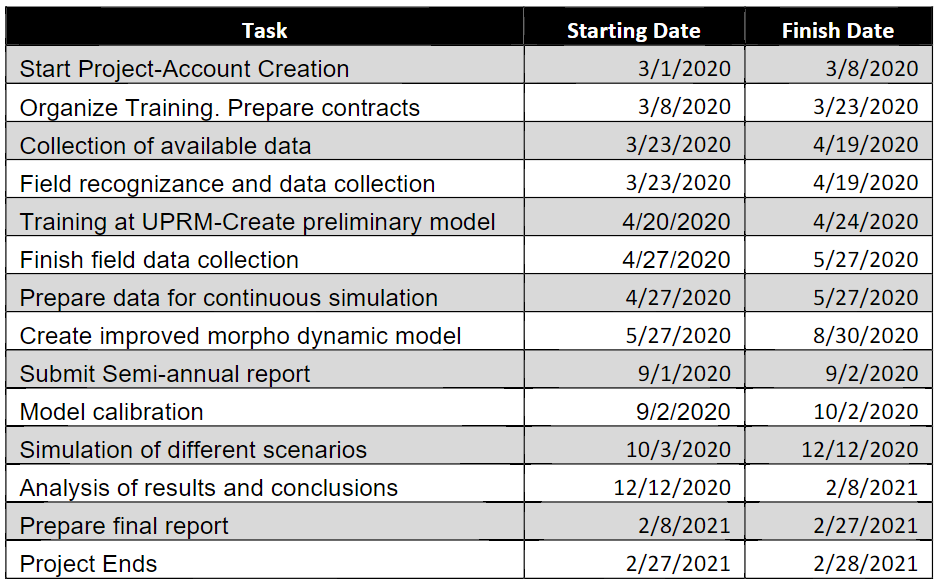
Timeline of Activities
Methods, procedures and facilities
The following methodology will be followed:
-
Organize training on iRIC emphasizing 2D and 3D simulations. Personnel from USGS and iRIC development team will offer a four-day training workshop at the University of Puerto Rico, Mayag&uulm;ez. The seminar will be organized by the PRWRERI with the support of the CRC. Dr. Jonathan Nelson and two other members from the USGS confirmed availability to offer the seminar in Puerto Rico. The tentative date is April 21 to 24, 2020. The last day will be dedicated to a field trip to receive training on how to collect data for modelling input.
-
Collect available hydrologic, hydraulic, and sediment data for the lower valley of Río Grande de Añasco. Identify data sources and potential use for calibration and model input.
-
Field Recognizance: Obtain bathymetry and sediment data in the river and floodplain of the area of interest. Recommendations from the field trip conducted as part of the workshop will be included. A partial list includes:
- Surveying of the channel to determine the actual geometry in different areas, hydraulic characteristics as channel width and slope conditions.
- Identify geomorphological features that are present in the channel.
- Characterize the history of the floods in the zone.
- Identify changes caused by activities such as urban development, land-use changes, deforestation, agricultural practices, existing structures, meander cut-off, and natural events.
- Take samples of soils along the channel to obtain the representative particle grain size distribution and soil characterization.
- Analyze vegetation interaction with the hydraulic conditions of the channel.
- Prepare the morpho-dynamic model to simulate sediment transport as well as morphological changes of bed and banks.
-
Obtain or develop time series of discharge events (hydrographs and continuous simulations) to use as input to the morpho-dynamic model.
-
Attempt to calibrate the morpho-dynamic model with water elevations collected from historic events.
-
Simulate different scenarios including extreme events and long-periods of regular flows. Use computer simulations to run several scenarios and determine the possible morphologic evolution of the river channels.
- a. Determine changes in bed material mobility in terms of particle size for different flow frequencies and simulation times.
- b. Estimate changes in channel dimensions and meandering due to changes in flow conditions.
Computational facilities will be provided by the Puerto Rico Water Resources and Environmental Research Institute.
Related Research
Channel evolution and geomorphic impacts
Changes in channel geomorphology occur constantly with time. This evolution is determined by the geologic composition of the banks. Banks in which the geologic composition is mostly sand and coarser particles are more susceptible to erosion than those dominated by cohesive material or rock outcrops. When water begins to erode the channel banks, the non-cohesive material becomes unstable until the bank failure occurs. Failure can also occur in cohesive material because the erosion process will depend on the shear stress forces exerted by the water into the bank and the resisting force of the bank material. In banks composed of cohesive material, failures occur in the “failure plane” where the shear stress of water exceeds the shear strength resisted by the bank [6], [12]. Other types of failures that contribute to bank erosion are cantilever, soil fall, rotational slips, and slab failures [13].
In the long term, the river changes the planform along the valley. Several processes occur simultaneously which, acting together, lead to the evolution of landscape at a macro scale and are the focus of fluvial geomorphology. Erosion and sediment transport are two mechanisms responsible for changes in the geomorphology of the channel. The concentration of sediment transport depends directly on the amount of flow, velocity, angle of attack, and depth of the channel. Other factors that govern bank erosion are the antecedent condition, vegetation growth, rainfall intensity, and man-made impacts. The sediment load, especially the suspended load, increases when the flow increases due to the improvement of its soil detachment capability [14,15]. If the channel section has vegetation in the banks and in the channel bottom, the resulting velocity of water and shear stress will decrease. Vegetation effects depend on roots, which help as a streambank stabilization device [16]. This type of stabilization can reduce the water velocity in the riverbanks which will reduce the impact of erosion. Erosion could be also produced by man-made impacts on the channel. Bridges, pipes, weirs, and dams are structures capable to expand or reduce the flow area in the channel in a form that provides an increase or decrease in erosion, but it can also generate deposition of sediments in the surrounding zones of the structure.
The time scale is an important factor to consider in the channel’s geomorphological evolution. Some geologic compositions are more susceptible to erosion than others. Under normal natural conditions, the evolution in channel geomorphology will take months, years, or even centuries depending on the flow and geology, but significant changes in the longitudinal profile of the channels can take over ten years. Low-frequency and high flow events can move large quantities of sediment, however, it is difficult to link the amount of flow and sediment transport with the geomorphological changes of the channel under these circumstances [6]. To determine the historic geomorphic evolution is necessary to collect data of sediment movement, streamflow, climate, frequency, and magnitude of events such as floods and human activities [17]. These data will help to understand the geochronology of the channel system and establish a precedent of what happened in the channel and what could occur in the future. There are analyses; such as, dendrochronology (the study of the tree rings to determine the time intervals), archeological methods, varves (the lamination of lacustrine deposits) and other methods that help to identify historical events and geomorphic processes [18, 19].
According to the natural behaviour of the river channel and the human interaction, the river suffers a series of stages to reestablish its dynamic equilibrium [20,21,22]. The channel evolution theory helps to determine in which stage of evolution is the river reach at present and establish a hypothesis on its future changes.
Part of the channel evolution includes channel migration [23] which encompasses many types of movements such as, translation, extension, expansion, rotation, and possible combinations of these movements (Figure 2). Translation movement occurs when the channel moves downstream without altering its shape. The extension movement occurs when the channel moves in the lateral direction increasing its amplitude and length. The channel expansion increases the amplitude and the length of the entire shape. Rotation occurs when the channel bend is rotated to a different orientation. Normally the river can change in a combination of these patterns and will depend on the geometry of the channel and the geologic strata that form the banks.
According to Anthony, et al. [22], the evolution of the channel does not have a good correlation between channel morphology and sediment size but, a good correlation can be obtained from the channel width and water depth using an index of silt and clay. Using the mean annual flow and the percentage of silt and clay, Schumm [18] developed a series of empirical equations. These equations provide an idea of the river evolution in a section depending on the channel discharge and sediment load. From a geomorphological point of view, these equations provide characteristics of the river geometry, discharge, and sediment using simple wave-like meander patterns.
Anthony et al. [22] proposed another set of equations for non-cohesive alluvial channels which requires the initial values of average flow, particle size, mean diameter, and dimensionless Shield number. These equations involve a predetermined coefficient and exponents of discharge, grain size, and slope. These formulations were derived from limited field and laboratory data and none have been tested for rivers in Puerto Rico or any tropical island. Computer software for the simulation of movable boundary hydraulics and sediment transport will be used to estimate the channel evolution.
Sediment transport and morpho-dynamics modelling
Computer software for simulation of movable boundary hydraulics and sediment transport will be used to estimate the channel evolution. The sediment transport in a natural channel is very complex, and if human interaction is present in the channel, the complexity increases. Movable boundary computer models are capable of simulate changes in cross-sectional geometry due to sediment transport. Numerical models to reproduce the evolution of meandering channels, taking bank erosion into consideration, have been developed for beds and banks made of uniform material since the decade of the ’90s. Meander evolution models were first developed for uniform material.
channels [24]. Others account for the deformation of narrow, deep erodible channels [25]. More recent models include slump blocks mechanisms and bank deposition [26].
The selected model does 2D river flow and bed morphodynamics, including river confluence, bank erosion, bedload-suspended load simulations in mixed-size sediment, bedload layer model and fixed bed model, and variable sediment supply rate from upstream. The model is based on the work of Yang and Shimizu [27] and the more recent version is called Nays2DH. Other solvers from the iRIC project that could be used are FastMECH and Morpho2D [9].
This model is appropriate for wide and narrow channel rivers. 2-D modeling can provide a better understanding of the hydraulic conditions and sediment transport processes contributing to the future evolution of the channel; as well as, provides an accurate representation of the complex hydraulic conditions, sediment transport, and channel evolutions, The model is also appropriate for alluvial valleys and wide-open flood plains.
Training Potential
This project will benefit at least one graduate student and two undergraduate students while assisting in data collection. Dr. Jonathan Nelson from USGS and two partners will travel to Puerto Rico to offer a training workshop on iRIC modules. Twenty people (20), including students, faculty members, USGS personnel, specialists from government and municipalities agencies will participate in the hands-on hydraulics and morpho-dynamic training workshop.
References
-
Gould, W.A., Wadsworth, F. H., Quiñones, M., Fain, S.J. and Alverez-Berríos, N.L. Land Use,
Conservation, Forestry, and Agriculture in Puerto Rico, Forests, July 2017.
-
https://www.miprv.com/ayudas-para-agricultores-ganaderos-y-duenos-de-tierras-en-la-cuenca-del-
rio-grande-de-anasco/, Accessed on December 18, 2019.
-
Días, J.R., Jordan, D.G., Water Resources of the Rio Grande de Añasco Lower Valley, USGS Water
Resources Investigations Report 8504237, Department of the Interior, 1987.
-
Silva-Araya, W.F., Geomorphic Impacts in rivers of Puerto Rico before and after Hurricane María
using UAV’s, Puerto Rico Water Resources and Environmental Research Institute, on-going research.
-
C. Thorne, R. Hey and M. Newson, Applied Fluvial Geomorphology for River Engineering and
Management, Chichester, England: John Wiley & Sons, 1997.
-
R. Charlton, Fundamentals of fluvial Geomorphology, NY: Routledge, 2008.
-
US Department of Interior (USGS), "Alluvial deposits," 3 Sep. 2004. [Online]. Available:
http://geomaps.wr.usgs.gov/archive/scamp/html/scg_surf_alluv.html. [Accessed 4 April 2016].
-
M. Garcin and B. a. P. R. Poisson, "High Velocity Geomorphological Processes in a Tropical Area: the
Remparts River case study," Geomorphology, pp. 335-350, 2004.
-
iRIC Software, https://i-ric.org/en/about/, Accessed December 2019.
-
P. H. Gleik, The World's Water, Washington: Island Press, 2009.
-
D. Rosgen and L. Silvey, Field Guide for Stream Classification, Pagosa Springs, CO: Wildland
Hydrology books, 1998.
-
D. J. Anthony, M. D. Harvey, J. B. Laronne and M. P. Mosley, Applying Geomorphology to.
Environmental Management, Denver, CO: Water Resources Publications, LLC, 2001.
-
D. S. Biedenharn, C. M. Elliot and C. C. Watson, The Wes Stream Investigation and Stream Bank
(2011). Stabilization Handbook, Vicksburg, MS: U.S. Army Engineer, 1997.
-
D. a. S. F. Simon, Sediment Transport Technology, Colorado: Water Resources Publications, 1992.
-
P. Julien, Erosion and Sedimentation, Cambridge, UK: Cambridge University Pres, 2010.
-
Georgia Environmental Protection Division, "Stream Bank and Shoreline Stabilization, Techniques
to Control Erosion and Protect Property," Department of Natural Resources, Environmental Protection Division, Georgia, 2011.
-
L. B. Leopold, M. G. Wolman and J. P. Miller, Fluvial Processes in Geomorpholgy, San Francisco: W.
H. Freeman and Company, 1992.
-
D. Knighton, Fluvial Forms and Processess, A New Perspective, Great Britain: Oxford University
Press inc., 1998.
-
J. Collison, "Channel Evolution Model," Stream and Watershed Restoration, [Online]. Available:
https://riverrestoration.wikispaces.com/Channel+evolution+model. [Accessed 12 June 2016].
-
Vermont Department of Environmental Conservation, "An Introduction to River Channel Evolution,"
Vermont River Channel Evolution Models, 12 Apr. 2011. [Online]. Available: http://dec.vermont.gov/sites/dec/files/wsm/rivers/docs/rv_introduction_to_channel_evolution.pdf. [Accessed 12 June 2016].
-
Simon and M. Rinaldi, "Disturbance, Stream Incision, and Channel Evolution: The Roles of Excess
Transport Capacity and Boundary Materials in Controlling Channel Response," Geomorphology, vol. 79, no. 3-4, pp. 361-383, 2006.
-
D. J. Anthony, M. D. Harvey, J. B. Laronne and M. P. Mosley, Applying Geomorphology to
Environmental Management, Denver, CO: Water Resources Publications, LLC, 2001.
-
K. Van Wilson, Jr. and D. P. Turnipseed, "Geomorphic Response to Channel Modifications of Skuna
River at the State Highway 9 Crossing at Bruce, Calhoun County Mississippi," U.S. Geological Survey, Jackson, Mississippi, 1994.
-
Nagata, N., Hosoda, T. and Muramoto, Y. (2000). “Numerical analysis of river channel processes
with bank erosion”, J. Hydraul. Eng., 126(4), 243-252.
-
Shimizu, Y. 2002. “A method for simultaneous computation of bed and bank deformation of a
river.” River Flow 2002, Int. Conf. on Fluvial Hydraulics, Louvain-la-Neuve, Belgium, 793–801.
-
Dulal, K.P., Kondo,Y., Kimura I., Shimizu, Y. and Parker, G. , 2010, “Prediction of evolution process
in free meandering rivers using 2D numerical model considering slump blocks and inner bank deposition”, River, Coastal and Estuaring Morphodynamics: RCEM 2009, Vionnet et al. (eds), Taylor and Francis Group, London.
-
Jang, C. and Shimizu Y. “Numerical simulation of relatively wide, shallow channels with erodible
banks The tentative Journal of Hydraulic Engineering, ASCE, Vol. 131, No.7, pp.565-575, 2005.
|
|