Title:
Geomorphic impacts in rivers of Puerto Rico before and after Hurricane Maria using UAV’s
Duration: March 1, 2018 to February 28, 2019
Sponsoring Agency: United States Geological Survey (USGS)
Project Strategy, Technical Assistance
and Training Approaches
1. Project Narrative
Quantitative research on the prediction of geomorphological changes
of floodplain in tropical island rivers is scarce and, in Puerto Rico, it is
almost non-existent. The situation is the same with respect to human impacts on
rivers, particularly mining operations. The lack of historical data and field measurements
limits the estimation of changes in river morphology during the useful life of
major hydraulic structures or planning land development covering the range between 50 and 100
years. Moreover, the crossing of Hurricane María over Puerto Rico in September 2017 created
major changes in planforms and landscaping of rivers in Puerto Rico. Under normal circumstances
those changes had taken several decades or even centuries to occur. This proposal will quantify
geomorphologic changes and the impact of Hurricane Maria on two major rivers of Puerto Rico.
Río Grande de Añasco will be studied with a focus on a flood plain evolution and Río
Grande de Loíza. It will focus on the impacts of extreme events in previously perturbed
environment; specifically, river mining activities. State-of-the-art movable boundary hydraulic
models will be developed using precise topographic data generated after Hurricane María
supplemented with field measurements. Several scenarios of future behavior of streams will be
simulated. This project will bring quantitative knowledge of geomorphic impacts in tropical rivers,
including extreme events. A data base with new information on river characteristics after passage
of an extreme tropical phenomenon will be available for further research. Possible improvements of
numerical models for predicting the effects of such phenomena will be considered. This information will
be useful in practical applications, particularly hazard mitigation and infrastructure design.
Statement of regional or State water problem
On the morning of September 20th, 2017, the powerful Hurricane María landed in Puerto Rico as
a Category 5 hurricane causing the biggest disaster in Puerto Rico since the last century. Maria
also severely affected other islands in the Caribbean, including the U.S. Virgin Islands. High
sediment and debris loads accompany huge floods capable of destroying bridges, roads, culverts
and damaging at least one dam. This event caused major impacts in the rivers. Major changes in
planforms and landscaping occurred that, under normal circumstances, had taken several decades
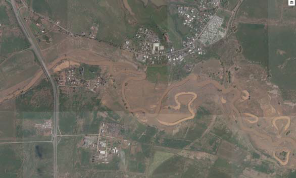
or even centuries to occur. Figure 1 shows a portion of Río Grande de Añasco crossing Highway
PR-22 the day after the hurricane. It is noticeable that the formation of oxbows and the extension of
flooding occurred in a period of approximately two days. Similar effects have occurred in many
rivers in the island, but quantitative research on prediction of geomorphological changes of
floodplain in rivers in tropical islands is scarce and, in Puerto Rico, it is almost non-existent.
The situation is the same with respect to human impacts on rivers, particularly mining operations.
The passage of Hurricane Maria transformed the landscape of fluvial valleys in Puerto Rico.
Presently there are no engineering studies in geomorphology of rivers in Puerto Rico and the
effects of extreme events in the Carribean island. Recent events provide a unique and, probably
once in a lifetime opportunity to quantify geomorphologic impacts of extreme events in the
Caribbean Island. Comparison between present and past conditions provide valuable engineering
information for design of infrastructure and disaster prevention which at the time was non-existent.
Figure 1: Impact of Hurricane Maria at Rio Grande de Añasco near bridge over
highway PR-22
Statement of results and benefits
This project will bring the following benefits:
-
New knowledge of geomorphic impacts in tropical rivers, including extreme events. A database with
new information on river characteristics after passage of and extreme tropical phenomenon will be
available for further research.
-
Recommendations for improvement of numerical models for predicting the effects of such
phenomena useful for hazard mitigation and infrastructure design.
-
Recommendations to improve resilience in infrastructure (bridges, culverts, roads, levees and
dams) as well as agriculture and rural cities.
Nature, Scope and Objectives of the project
Nature
The geomorphological characteristics of the rivers are in constant evolution. Sediment transport depends
on the geologic composition of the area, river characteristics, climatologic and hydrologic conditions. The
interaction of these factors produce continuous changes visible during long periods of time. The fluvial
systems have major impacts in economic development. Large agricultural areas, mining, fishing, urban
water supply sources, urban and industrial developments and, other economic activities related to natural
resources. These occur within alluvial valleys and are important components of river management. Also, the
fluvial system is the scenario of natural disasters such as floods, exacerbated bank erosion, channel
migration, and river aggradation or degradation.
Geologic formations determine the soil composition. Sedimentary and heavily weathered rock
formations are vulnerable to break into loose soil in a short period and contribute to the sediment transport
process. This process depends on layer compaction, grain size, the angle of repose and the layer’s
inclination angle of the formation. Along the river stream, these layers are naturally exposed by the process
of constant erosion. Water erosion is the action of a surface flow or raindrops impacts which separates the
soil particle. The particle may be moved from the point of origin into a stream and transported downstream
of the river or land surface. The erosion process depends on the conditions of the soil surface which
include: geometry, slope, surface roughness, water depth, shear stress exerted by the water on the surface
and the maximum shear stress that the layer formation is able to resist.
The capacity to transport sediments as bed material load or washload increases when flow discharge
increases. The increase of sediment transport depends on the hydrological characteristics and the existing
geologic formation. Rain causes surface runoff which goes into channel, increasing the water velocity and
depth. This action increases erosion of the exposed surface and sediment transport toward the downstream
river reaches. Under normal conditions, this process slowly changes channel alignment and shape; as well
as, the floodplain landscape. The same changes occur at a much faster rate, in short periods of time, with
low-frequency events such as hurricanes or tropical storms. Either way, the evolution of the geomorphology
is more evident in alluvial valleys with non-cohesive soils. The alluvial material is a stratified deposit of
gravel, sand, silt, clay and other debris carried by the streamflow from a high altitude to a lower ground
elevations of the valley. The climate conditions in the tropical regions impact the rate at which
geomorphological changes occur, accelerating the evolution of the river processes. Climate change in
the tropics is expected to increase runoff and, consequently, aggravate floods and hazard conditions.
Erosion can be accelerated or decelerated by human impacts, which may affect the natural equilibrium.
Some of these human impacts are river mining, construction of bridges and dams.
Previous research focused on protecting structures such as bridges and culverts from local scour;
and regulations are available to control their impact over the river; however; much work need to be done in
understanding channel and floodplain evolution on a larger scale both, in time and space.
The alluvial valleys in Puerto Rico are located near coastal areas and normally show a meandering
pattern. The meanders are part of the constant evolution of the geomorphology of these zones. Oxbow lakes
and dry channels are visible by examining aerial photos. However, quantitative research on prediction of
geomorphological changes of floodplain in rivers in tropical islands is scarce and, in Puerto Rico, it is
almost non-existent. The situation is the same with respect to human impacts on rivers, particularly mining
operations.
The lack of historical data and field measurements limits the estimation of changes in river
morphology during the useful life of major hydraulic structures or planning land development covering the
range between 50 and 100 years. The use of state-of-the-art movable boundary hydraulic models combined
with precise topographic data and geographic information systems, supplemented with field recognizance
presents an alternative for development of possible scenarios on the future behavior of streams.
Scope
This project quantifies geomorphologic changes and the impact of Hurricane Maria on two
major rivers of Puerto Rico. Ro Grande de Añasco and Río Grande de Loíza.
The first river is being studied focusing on a flood plain evolution (See Figure 1), while the
second river analysis focuses on the impacts of extreme events in previously perturbed environment;
specifically, river mining activities.
Data collection and documentation of river characteristics include planform, cross-sections,
longitudinal profiles and sediment data. Data collected will be compared with previously available
information to assess the magnitude of changes that occurred during this event. Data collection
will be done by using Unmanned Aerial Vehicles (UAV), commonly known as “drones”, equipped
with high precision photogrammetry. In addition, field recognizance and, Light Imaging and
Ranging (LIDAR) data available from USGS will supplement the data acquisition. All the
information will be stored in a database accessible to other researchers.
Objectives
The objective of this research is to perform a geomorphologic characterization of two rivers with
different geologic conditions supported by state-of-the-art UAV and photogrammetry technology.
One river is representative of flood plain evolution and the other is a mountain river impacted by
river mining activities. The geomorphologic impact will be done in two different aspects: channel
evolution during a long period of time (more than 20 years) and, channel evolution after impact of
the extreme event produced by Hurricane María in September of 2017.
Timeline of Activities
Methods, procedures and facilities
The following methodology will be done:
-
Identify the geologic characteristics of the channel zone using geological maps and
verifying the geological conditions on the field.
-
Field Recognizance: Establish geomorphologic differences in the chosen areas of interest
(AOIs). These include channel width, bank height, meander wavelength, river flow and
velocity.
-
Field Recognizance: Determine the state of dynamic equilibrium of the AOIs and establish
the historical changes with respect to the dynamic equilibrium. Channel evolution theory
and a stream classification such as Rosen will be used for this task.
-
Identify sources of hydrological and hydraulics data. The use of data for calibration and
model input depend on the findings during the process of gathering information.
-
Major changes in the river geomorphology occur during extreme weather conditions such
as tropical storms and hurricanes. The frequency of hurricanes is expected to increase due
to climate change. Therefore, some scenarios with higher frequency of extreme weather
events will be tested, including data from Hurricane Maria.
- Conduct field investigation combined with Lidar elevation data to characterize existing
conditions of the chosen rivers. This will include:
-
Surveying of the channel to determine the actual geometry of the channel in
different areas, hydraulic characteristics as channel width and slope conditions.
-
Identify geomorphological features which are present in the channel.
-
Characterize the floods history in the zone.
-
Identify changes caused by human activities (urban development, land use
changes, deforestation, agricultural practices, river mining, existing structures, land
use records and natural events).
-
Take samples of soils along the channel to obtain the representative particles
grain size distribution and soil characterization.
-
Vegetation interaction with the hydraulic conditions of the channel.
-
Use georeferenced photogrammetry obtained from equipped UAV’s to determine the
ground and river topography to generate spatial information using GIS. This technique
improved during the last years and is capable of providing accurate topographic data
-
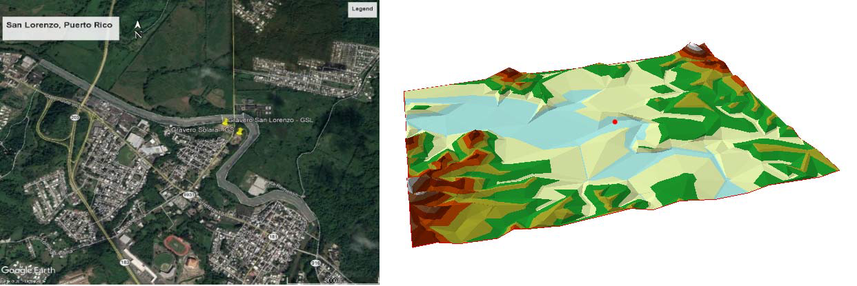
Data collected will be processed and analyzed to obtain accurate representation of the
sites hydrologic and geomorphologic conditions. Figure 3 shows a comparison between
expected GIS data and aerial photos of Río Grande de Loíza at San Lorenzo.
-
Use computer simulations to run several scenarios and determine the possible
morphologic evolution of the river channels:
-
Determine changes in bed material mobility in terms of particle size for different
flow frequencies and simulation times.
-
Establish potential changes in channel dimensions and meandering due to changes
in flow conditions.
-
Determine impacts of river dredging of Río Grande de Loíza at San Lorenzo by
testing HEC-RAS recently added capabilities.
Computational facilities will be provided by the Puerto Rico Water Resources and
Environmental Research Institute.
Figure 2: Comparison of aerial photo and GIS processed digital elevation model
Related Research
Channel evolution and geomorphic impacts
Changes in channel geomorphology occur constantly with time. This evolution is
determined by the geologic composition of the banks. Banks in which the geologic composition
are mostly sand and coarser particles that are more susceptible to erosion than those dominated by
cohesive material or rock outcrops. When water begins to erode the channel banks, the non-cohesive
material becomes unstable until the bank failure occurs. Failure also can occur in
cohesive material because the erosion process will depend on the shear stress forces exerted by the
water into the bank and the resisting force of the bank material. In banks composed with cohesive
material failures occurs in the “failure plane” where the shear stress of water exceeds the shear
strength resisted by the bank. Other type of failures that contribute to the bank erosion are
the cantilever, soil fall, rotational slip and slab failures.
In the long term, the river changes the planform along the valley. Several processes occur
simultaneously which, acting together, leads to the evolution of landscape at a macro scale and are
the focus of fluvial geomorphology. Erosion and sediment transport are two mechanisms
responsible for changes in the geomorphology of the channel. The concentration of sediment
transport depends directly on the amount of flow, velocity, its angle of attack and depth of the
channel. Other factors that govern bank erosion are the antecedent condition, vegetation growth,
rainfall intensity and man-made impacts. The sediments load, especially the suspended load,
increases when the flow increases due to the improvement of its soil detachment capability.
If the channel section has presence of vegetation in the bank and in the channel bottom, the
resulting velocity of water and shear stress will decrease. Vegetation effects depend on roots,
which help as a streambank stabilization device. This type of stabilization can reduce the
water velocity in the riverbanks which will reduce the impact of erosion. Erosion could be also
produced by man-made impacts on the channel. Bridges, pipes, weirs, dams are structures reduce the
flow area in the channel in a form to provide an increase or decrease the erosion, but it can also
generate deposition of sediments in the surroundings zones of the structure.
The time scale is an important factor to consider in the channel’s geomorphological
evolution. Some geologic compositions are more susceptible to erosion than others. Under normal
natural conditions the evolution in channel geomorphology will take months, years or centuries
depending on the flow and geology, but significant changes in the longitudinal profile of the
channels can take over ten years. Low-frequency and high flow events are able to move large
quantities of sediment; however, it is difficult to link the amount of flow and sediment transport
with the geomorphological changes of the channel under these circumstances.
To determine the historic geomorphic evolution is necessary to collect data of sediment
movement, stream flow, climate, frequency and magnitude of events such as floods and, human
activities. This data will help to understand the geochronology of the channel system and
establish a precedent of what happened in the channel and what could occur in the future. There
are analyses; such as, dendrochronology (study of the tree rings to determine the time intervals),
archaeological methods, varves (lamination of lacustrine deposits) and other methods which help
to identify historical events and
geomorphic processes.
According to the natural behavior
of the river channel and human
interaction, the river suffers a series of
stages to re-establish its dynamic
equilibrium. The channel
evolution theory helps to determine in
which stage of evolution is the river reach
at present and establish a hypothesis on its
future changes.
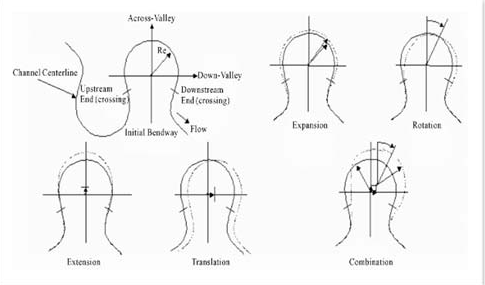
Part of the channel evolution
includes channel migration which
encompasses many types of movement;
such as, translation, extension, expansion, rotation and possible combinations of these movements
(Figure 33). Translation movement occurs when the channel moves downstream without altering
its shape. The extension movement occurs when the channel moves in lateral direction increasing
its amplitude and length. The channel expansion increases the amplitude and the length of the
entire shape. Rotation occurs when the channel bend is rotated to a different orientation. Normally
the rivers can change in a combination of these patterns and will depends on the geometry of the
channel and the geologic strata that conforms the banks.
Figure 3. Different Channel drainage movement
According to Anthony, et al. and Booth and Fischenich, the evolution of the
channel does not have a good correlation between channel morphology and sediment size but, a
good correlation can be obtained from the channel width and water depth using an index of silt
and clay. Using the mean annual flow and the percentage of silt and clay, Schumm developed a
series of empirical equations. These equations provide an idea of the river evolution in a
section depending on the channel discharge and sediment load. From a geomorphological point of
view, these equations provide characteristics of the river geometry, discharge and sediment using
simple wave-like meander patterns.
Anthony et al. proposed another set of equations for non-cohesive alluvial channel
which requires the initial values of average flow, particle size mean diameter and, dimensionless
Shield number. These equations involve a predetermined coefficient and exponents of discharge,
grain size and slope. These formulations were derived from limited field and laboratory data and
none has been tested for rivers in Puerto Rico or any tropical island.
Computer software for simulation of movable boundary hydraulics and sediment transport
will be used to estimate the channel evolution.
Sediment transport and geomorphological modelling
Computer software for the simulation of movable boundary hydraulics and sediment transport
are used to estimate the channel evolution. The sediment transport in a natural channel is very
complex and, if human interaction is present in the channel, the complexity increases. Movable
boundary computer models will be used to simulate changes in the cross sectional geometry due
to sediment transport. The most appropriate sediment transport functions are selected by using
criteria associated with flow and sediment conditions that most resemble those used for derivation
of the empirical function. One-dimensional (1-D) and two-dimensional (2-D) models are used.
Some advantages of using these models are: 1D modeling allows efficient assessment of hydraulic
Figure 3. Different Channel drainage movement by
condition and sediment transport balance. It uses a database which includes cross sectional data
and provides boundary conditions that can be used with the 2-D models. These models are
appropriate for narrow channel rivers. 2-D modeling can provide a better understanding of the
hydraulic conditions and sediment transport processes contributing to future evolution of the
channel. Provides an accurate representation of the complex hydraulic conditions of the channel
and more detailed results than the 1-D models; as well as; estimates of the possible meander
displacement along the floodplain with time. These models are more appropriate for alluvial
valleys and wide open flood plains.