|
|
|
|
1. Project Partner
Joined for a Better Environment
- Junta de Planificación de Puerto Rico
- Puerto Rico Water Resources and Environmental Research Institute
- University of Puerto Rico at Mayagüez
2. Researchers

Jorge Rivera Santos Ph.D.
Professor Civil Engineering and Surveying Department
University of Puerto Rico
Mayagüez Campus jorge.rivera40@upr.edu

Walter Silva Araya, Ph.D.
Professor Civil Engineering and Surveying Department
University of Puerto Rico
Mayagüez Campus walter.silva2@upr.edu

Sigfredo Torres
Consultant in Geohydrology
Email: stgtorres@msn.com
3. Students
Andrea Figueroa Soto
Bachelor's Degree: Civil Engineering
Graduation Date: May 2020
e-mail: andrea.figueroa2@upr.edu
Micheal A. Quiñones Ríos
Undergraduate: Civil Engineering
e-mail: micheal.quinones@upr.edu
Jonatan G. Cuevas Plaza
Undergradutas: Civil Engineering
Graduation Date: May 2023
e-mail: jonatan.cuevas@upr.edu
Xamara X. Binet Flores
University of Puerto Rico at Mayagüez
e-mail: xiamara.binet@upr.edu

Oscar Martinez Pinilla, PE, Ph.D(c)
Bachellor Degree: Civil Engineering
Master Degree : Environmental Engineering
Ph.D. Student: Water Resourses Engineering
Expected Graduation Date: May 2020
e-mail: oscar.martinez4@upr.edu
Sebastían García Cordero
Graduate of University of Puerto Rico at Mayagüez
|
|
|
|
|
Update to Regulations for Design of Stormwater
Systems in Puerto Rico
|
Duration: June 18, 2019 to December 21, 2020
Project Strategy, Technical Assistance
and Training Approaches
1. Project Narrative
The Puerto Rico Water Resources and Environmental Research Institute (PRWRERI) is a research and engineering consulting center located at the Mayagüez Campus of the University of Puerto Rico (UPRM). The Institute is one of 54 similar water centers established throughout the United States and its territories by Act of Congress in 1964 (P.L. 88-379) and presently operating under Sections 104-B and 104-G of the Water Research and Development Act of 1984 (P.L. 98-42), as amended. The PRWRERI was established on April 22, 1965 and since has received an annual federal fund allocation from the US Congress through the US Geological Survey.
The PRWRERI conducts research and consultations aimed at resolving local and national water resources problems, trains scientists and engineers through hands-on experience in research and consultation, and facilitates the incorporation of research results into the knowledge base of water resources professionals in Puerto Rico, U.S. and abroad. To accomplish these objectives, the Institute identifies Puerto Rico's most important water resources research needs, allocates federal funds to the most relevant and meritorious research projects, encourages and supports the participation of students in funded projects, leverage funds applying to other consulting and research opportunities, and disseminates results to scientists, engineers, and the general public.
Since its conception, the Institute has sponsored a substantial number of research and consulting projects, supported jointly by the federal, state, private, and University of Puerto Rico's funds. Through its website (http://prwreri.uprm.edu/), the Institute's work is more widely known to the Puerto Rican and world communities, at the same time, it provides means of information transfer with regard to the reports produced through the institute's research activities.
The Institute has become a recognized alternative engineering consultant to the industry, private and government sectors on water resources and environmental issues. It is direct recipient of federal funds from government agencies such as EPA, USGS, FEMA, NRCS, and NOAA and of pass-through federal funds from state agencies like DNER and PREQB.
The PREWERI developed expertise in the use of advanced engineering techniques such as GIS analysis, remote sensing, state of the art computer modelling, advanced optimization using traditional and as well as genetic algorithms for model calibration, and water resources planning/ and management. In environmental engineering the PRWRERI has done work in water quality monitoring, and water treatment processes and design. More information about the trajectory and experience of the PRWRERI can be found at http://prwreri.uprm.edu/.
Statement of regional or State water problem
The goal of this project is the preparation of the Stormwater Design Standards, Performance Criteria and Procedures for Puerto Rico. The new regulations will incorporate design and performance criteria based on tested hydrologic and hydraulic engineering methodologies, design of low-impact development measures, computational methods and computer software supported by scientific knowledge and experience. The most recent and complete data available for Puerto Rico will be used to update the regulations. Climate change and sea level rise considerations will be included to increase resilience of new storm sewer systems or retrofitting of existing ones. Special considerations for the karst will be revised for possible adoption.
Statement of results and benefits
The PRWRERI has engaged in other projects that are similar in nature to the proposed project. These are guidelines that establish procedures and design criteria for engineering activities regulated by federal and state government agencies. Three of these projects are presented.
-
Guidelines for the Development of Hydrologic-Hydraulic Studies in Puerto Rico
This project was solicited by the DNER with the purpose to create guidelines that standardize and uniformize the whole process of analysis and design of water resources structures like flood control channel, bridges, culverts, stormwater drainage, etc. The objective was that all reports of hydrologic and hydraulic analysis as well as design, were submitted for evaluation to the DNER, follow specific procedures and, at the same time, give freedom of thinking and application of proved engineering practices. Dr. Walter Silva Araya and Dr. Jorge Rivera Santos co-authored the document, with collaboration of the DNER and Puerto Rico Planning Board personnel. This document was adopted by PRPB by means of resolution JP-HH-2016 and is required that all proponents off H-H studies follow these guides. More information can be found in the Appendix – Project Reference Form.
-
Development of alternatives for urban storm water flood mitigation at San Carlos Community in Dorado, Puerto Rico
This project consisted in the design of an urban storm water retrofitting project that will add hydraulic capacity to the old system, reducing the frequency of local floods in this community. The new system included a retention pond, enhancement of two parallel 60-in diameter pipelines, and replacement of old pipes within the community. The design and analysis was completed using state of the art computer modeling which allowed to examine all hydraulic structures performance in real time.
-
Guidelines for the Preparation of Sediment Transport Studies for Extraction of Aggregates from Rivers of Puerto Rico
This project responds to manage sand and gravel mining in rivers of Puerto Rico for protection and sustainability of the water resources. The guidelines where developed with participation of the DNER of Puerto Rico. It includes geomorphic stability analysis and modeling of sediment extraction operations to study scenarios for recovery of river stability. The guidelines take advantage of computer software simulations accessible to professional engineers.
-
Methodology of Evaluation of US Army Installation Bridges
This project was done under contract with the USACOE. The document presents an overview of and the guidelines for identifying bridges on the US Army Installations inventory that are at risk of scour and subject to channel instability. Techniques based on hydrology, geomorphology, and bridge design were studied for use in channel classification and reconnaissance. Field assessment methods also were investigated for use in identifying potential channel instability. Qualitative evaluation and quantitative engineering analysis also are presented herein. A scour evaluation form was prepared as an effort in minimizing the risk to the public, monitoring the structure, and recommending repair or replacement strategies.
Nature, Scope and Objectives of the project
Nature
The goal of this project is the preparation of the Stormwater Design Standards, Performance Criteria and Procedures for Puerto Rico. The new regulations will incorporate design and performance criteria based on tested hydrologic and hydraulic engineering methodologies, design of low-impact development measures, computational methods and computer software supported by scientific knowledge and experience. The most recent and complete data available for Puerto Rico will be used to update the regulations. Climate change and sea level rise considerations will be included to increase resilience of new storm sewer systems or retrofitting of existing ones. Special considerations for the karst will be revised for possible adoption.
Scope
The University of Puerto Rico at Mayagüuez agrees to perform a research, selection and preparation of the new Regulation with the best engineering practices available for design and analysis of stormwater systems, including:
-
Major and minor systems
- Detention and retention ponds
- Low-impact development measures for sustainable drainage
- Consideration of climate change conditions
- Consideration of analysis and design in the karst region
- Inclusion of retrofitting analysis and techniques for stormwater systems
- Training for the professional community on the use of the new Regulation
Arrangements will be made to involve and collaborate with the Department of Natural and Environmental Resources (DNER) of Puerto Rico, the US Environmental Protection Agency (USEPA) and the Puerto Rico Planning Board (PRPB) in this multi-agency project to be accomplished by experts from the Puerto Rico Water Resources and Environmental Research Institute (PRWRERI) of the University of Puerto Rico at Mayagüuez (UPRM) with collaboration of external partners. The new Regulations will be presented to the Planning Board members and to the regulated community through Public Hearings. Meeting minutes, monthly progress reports, all computer generated files, training materials, presentations, drafts and final version of the document in hard copy (2) and CD (2) will be delivered to the Planning Board of Puerto Rico. Printing educational material providing summarized information, illustrations and pictures for understanding and applications of the regulations, (trifold, fact sheet, pamphlet, or similar format) with full color, materials Dull Cover 80# will be provided. A total of 500 items will be delivered.
Objectives
The preparation of the Stormwater Design Standards, Performance Criteria and Procedures for Puerto Rico
Design Considerations
Design consideration for stormwater systems vary according to specific conditions. This section presents details of the more important topics to be included. The new regulations will be written in harmony with the current Guidelines for Preparation of Hydrologic-Hydraulic (H-H) Studies in Puerto Rico written by the proponents and adopted by the Planning Board and the Department of Natural and Environmental Resources of Puerto Rico in 2016 [1]. However, other topics are exclusive for storm water systems.
Current Storm Water Sewer Design Technologys
Significant advances in technology occurred in recent decades thanks to extensive use of digital computers. Some to be considered are:
- Improvement in hydrologic and hydraulic models capable of using fine spatial and temporal data and detailed description of physical phenomena affecting rainfall-runoff conversion and hydraulic routing.
- Extensive data processing and management using Geographic Information Systems.
- Low-Impact development (LID) alternatives and sustainable water management practices for reduction of potential impacts of water excess in urban or rural areas.
- Climate changes are expected to increase the intensity and frequency of extreme rainfall events in the Caribbean. Global Climate Models (GCM’s) and regionalization techniques produced estimates of probable changes in daily rainfall depths due to climate change scenarios. Such changes must be accounted for proper adaptation of stormwater sewer infrastructure.
The previous considerations are being incorporated into a series of digital products available through the Internet and are changing the way of doing design and analysis of stormwater systems. Puerto Rico is not an exception to these changes. Digital information on climatology, flows, land-use maps, soil surveys, digital elevation models, and design storms are readily available. Moreover, specialized software for design and analysis of specific system components such as culverts, LID, detention and retention ponds, and channel linings are available. A brief description of the major additions proposed for the new design standards is provided next.
Design Storms for Storm Sewer Systems in Puerto Rico Dimensionless Rainfall Temporal Distribution
In June 2016 the Planning Board of Puerto Rico adopted new guidelines for preparation of Hydrologic/Hydraulic studies [1]. This document contains dimensionless temporal distributions for design storms exclusively applicable to Puerto Rico for rainfall durations of 1-, 6-, 12- and 24-hours (see Figure in this page for an example). Rainfall depths at any site in Puerto Rico and the US Virgin Islands for different return periods and durations are obtained from the National Oceanographic and Atmospheric Administration (NOAA) Atlas 14 [2].
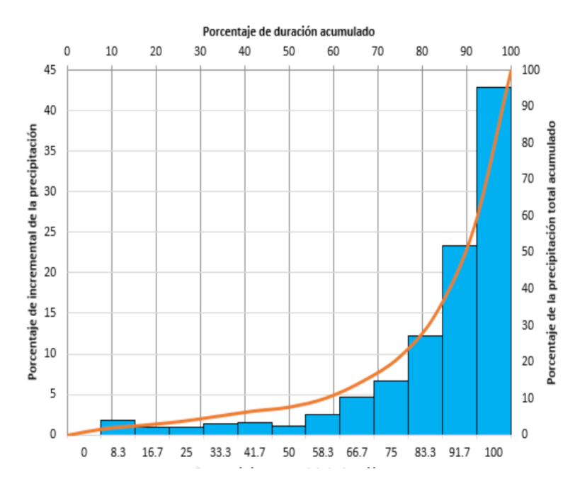
Figure 1: Dimensionless Rainfall
Durations and Frequencies for Design of Storm Sewer System
The present standards provide criteria for selection of return periods of design storms according to the land-use and the watershed area. They also divide the Island in regions providing intensity-duration-frequency curves for each region based on the superseded Technical Paper no. 42 (TP-42) [3] from the National Weather Service published in 1960. These criteria will be reviewed and updated based on currents engineering practices and the latest advances on hydrologic frequency analysis.
Likewise, present regulations are not clear on which rainfall durations and return periods should be used for design of structures for runoff control in urban development projects. Planning Regulation No. 34 (Reglamento de Lotificación y Urbanización), Section 14 (Manejo de Aguas Pluviales), Subsection 14.04 (Control de Escorrentía) ambiguously states that the designer must use “all rainfall intensities and durations” as design criteria. Even more, criteria for stormwater sewer design and detention ponds design are presently disarticulated. This inconsistency will be harmonized in the new standards.
Stormwater sewer systems consist of two principal components namely the minor and the major systems. The minor system is formed by the underground pipe network, while the major system consists of the channels, stormwater storage, ponds, large conduits, and roads in the ground surface. Major systems convey most of the water during extreme rainfall events. Criteria for selecting rainfall return periods and duration of design events could vary depending on which system will convey more water. Such criteria will be proposed as part of this project.
Estimation of Design Discharges and Hydrologic Abstractions There are several methods for runoff estimation. Commonly used and well-known methods are the Rational Method, the NRCS Curve Number (CN) method and unit hydrograph methods. These methods provide peak discharge or runoff volume. Unit hydrograph methods are usually combine with infiltration estimates to produce design hydrographs. CN, Horton and Green-Amp infiltration models are now readily accessible and incorporated in many commercial hydrology computer applications.
The commonly used Rational Method has been used for design of minor systems and is limited to small areas and short times of concentration. The CN Method has become widely used due to consideration of several factors for selecting CN values, its ease of application and its availability of CN values for a wide range of conditions. The method could be applied to large areas by dividing then into smaller sub-watersheds. It is also easy to apply using GIS because required information is readily available in shapefile format. The method is also used for analysis of sediment control measures in construction sites.
More detailed methods include a better description of the physical variables affecting infiltration and therefore; should be able to provide better estimates of hydrologic abstraction. Two of these methods are Horton and Green-Amp infiltration equations. They have been included in many computerized hydrologic models used for engineering applications. These methods are very important for design of LID measures.
The new standards will include a list of accepted methods for runoff estimation according to the project characteristics. Selection will be done based on degree of experience in application, scientific foundation and accessibility to the engineering community.
Hydraulic Models Hydraulic models have diversified in recent years. Complex models are now accessible to engineers. One example is the Environmental Protection Agency (EPA) powerful model named “Storm Water Management Model” (SWMM). This model provides dynamic solutions and routing hydrographs in complex systems. It includes ponds and other structures, as well as, capabilities to analyze LID measures. Many commercially available software uses SWMM as the basic engine for their computations. The new standard will provide a selection of better models for engineering design. Selection will be based on degree of experience in application, scientific foundation and accessibility to the engineering community.
Storage PondsStorage ponds are not included in the 1975 Standards. They are also not included in the guidelines for preparing Hydrologic/Hydraulic studies. However, they are vaguely considered in the PR Planning Regulation No. 34 (Subsections 14.04 and 14.05).
Besides been separated from both stormwater sewer design and H&H studies, they are an integral part of both. Ponds are commonly included as storage and regulation of water excess from stormwater system and are also a direct discharge into water bodies. To achieve a correct operation there must be an integration of the different components of the system. The new standards will integrate storage ponds inside the stormwater system with considerations for discharge into water bodies. The design of these structures will have the new LID perspective instead of the traditional design. Design method for hydrologic routing in storage pond and sizing of hydraulic structures for flow regulation will be explicitly incorporated.
Low Impact Development Measures Low impact development (LID) is a radically different approach to conventional stormwater sewer system design and management. It is belief that LID represents a significant advancement in the state of the art in stormwater design and management. LID enhances the ability to control runoffs in the source, reducing runoff volume and peaks resulting in less construction costs. In addition, LID protects surface and ground water quality, maintain the integrity of aquatic living resources and ecosystems, and preserving the physical integrity of receiving streams.
LID can achieve stormwater control through the creation of a hydrologically functional landscape that mimics the natural hydrologic regime. This objective is accomplished by (a) Minimizing stormwater impacts to the usable extent using techniques that include reducing imperviousness, conserving natural resources and ecosystems, maintaining natural drainage courses, reducing use of pipes, and minimizing clearing and grading; (b) providing runoff storage measures dispersed uniformly throughout a site's landscape with the use of a variety of detention, retention, and runoff practices; (c) maintaining predevelopment time of concentration by strategically routing flows to maintain travel time and control the discharge; and (d) implementing effective public education programs to encourage property owners to use runoff control measures and maintain the onlot hydrologically functional landscape management practices.
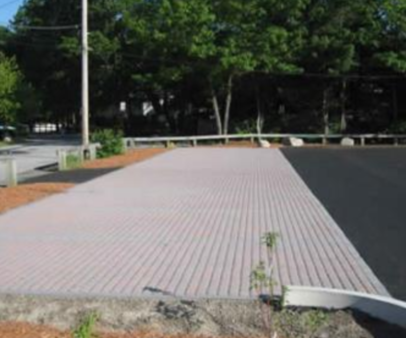
Image 1: Permeable Pavement
LID has numerous benefits and advantages over conventional stormwater management approaches. In short, it is a more environmentally sound technology and a more economically sustainable approach to addressing the adverse impacts of urbanization. By managing runoffs close to the source through intelligent site design, LID can enhance the local environment, protect public health, and improve community livability. The need for such an approach has never been greater. Stormwater programs, such as MS4, require that a wide array of complex and challenging ecosystem and human health protection goals be addressed. Essentially, LID consideration in the design of stormwater sewer systems will help accomplish these goals. Table 1 presentes some LID practices to be considered in the new Regulations.
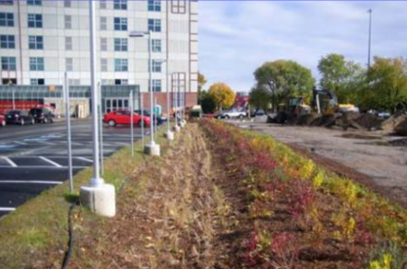
Image 2: Example of Vegetated Swale
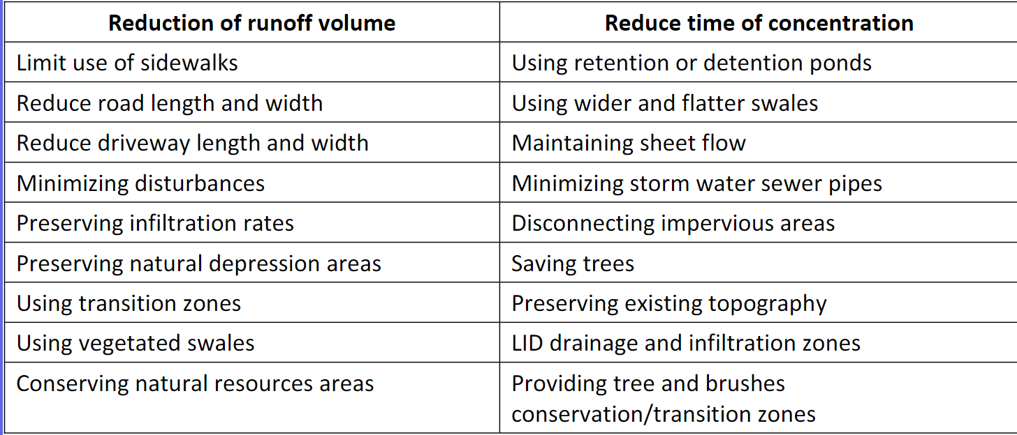
Table 1: Summary of LID technques for consideration in this project
Climate Change Effects
Climate projections for the Caribbean strongly suggest increase in magnitude and frequency of extreme rainfall events. Precipitation exceeding 3 inches in 24 hours will be more frequent [10]. Several regional studies were conducted in the Caribbean , mostly with the purpose of estimating sea level rise.
The most recent and detailed study on climate change was done by the group lead by Katharine Hayhoe [4]. Two sets of Global Climate Models (GCMs) were used, namely Couple Model Intercomparison Project version 3 (CMIP3) and Couple Model Intercomparison Project version 5 (CMIP5). Sixteen different models from CIMP3 and 16 models from CIMP5 were used running scenarios covering different time frames; however, most of them included a full daily time series from 1960 to 2099 (CIMP3) and 1950 to 2100 (CIMP5).
GCMs data must be downscaled to obtain estimates at smaller areas for other studies. Downscaling can be done using regional models, where grid sizes could vary between 10 and 50 km per side or using statistical models. Statistical models are useful to relate large-scale weather conditions with local climate. These models are useful to provide data at individual weather stations or at grid scales. Hayhoe et al. [4] used the Asynchronous Regional Regression Model (ARRM) to downscale data. Station data from several well-credited sources were used to generate daily precipitation data in 231 weather stations in the Caribbean; 77 of these stations are in Puerto Rico, as shown in the figure on the side [4]. Ahmed and Tsanis [5] developed a frequency analysis on precipitation data to evaluate the climate change impact on storm sewer systems in the City of Hamilton, Southern Ontario, and Canada. They adjusted probability distributions and used goodness-of-fit test to determine the most appropriate for estimation of rainfall depths for 24 hr-25 yr and 24 hr-5yr storms under climate change scenarios. Their procedure will be adapted for similar estimations in stations of Puerto Rico. This study will provide adjustments required in design storms to account for expected climate change conditions on sewer systems and ponds.
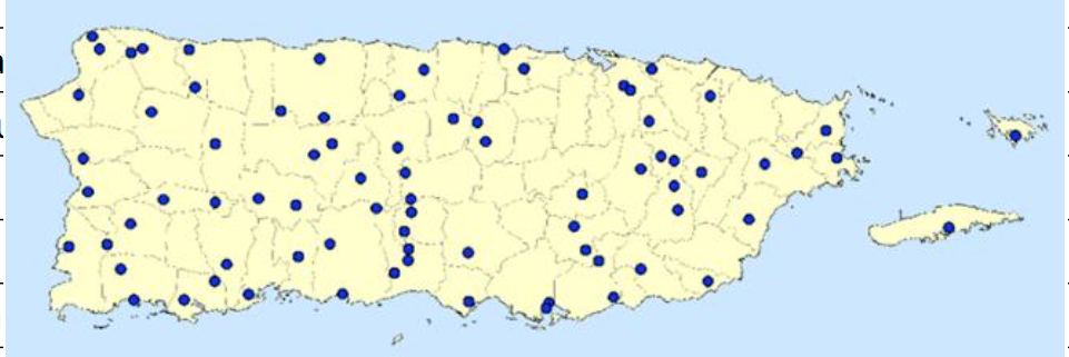
Image 2: Weather stations used in generating 24-hr precipitation projections in climate change scenarios
Sea level rise is expected to occur at a rate of about an inch every 15 years together with more severe rainstorms. Other studies predict higher values of sea level rise. Storm water systems in coastal areas will be affected by these changes. The new regulations must include special measures for adaptation of storm water systems to expected sea level rise scenarios. NOAA’ s Coastal Zone Exposure Mapper will be a useful tool to assist in decisions and techniques proposed.
Hydrology of the Karst
Karst is a physiographic, complex integrated mass-transfer system in soluble rocks with a permeability structure dominated by conduits dissolved from the rock and organized to facilitate the circulation of water. Karst is characterized particularly by special landforms and subsurface drainage. Mogotes, sinkholes, sinking streams, caves, and springs are typical of Karst terrain. They also bring about distinctive geologic-morphologic forms, and more strikingly, specific flora and fauna. Hydrology and hydraulics, although long-established sciences and engineering practices, cannot easily be applied to karst regions with their very complex drainage system. A special approach is therefore necessary to understand and predict water circulation in these areas. Evidently, karst phenomena have not been sufficiently and carefully studied worldwide.
Uncontrolled stormwater discharges from developed areas in the Karst have contributed to the collapse of sinkholes and loss of life, and infrastructure. In addition, water quality of washed developed areas may deteriorate the groundwater geo-chemistry of the local limestone aquifers which in turn may reduce the structural stability of the subsurface limestone rocks. Throughout the geologic history of the Karst of Puerto Rico, no substantial change in geo-chemistry is observed [6]. Advances in technology make new methods and instruments available for ground exploration on karst terrain. These methods combined with other techniques, such as hydraulic inundation methods, come to fill a gap in the determination of the hydraulic capacity of sinkhole mouths and underground conduits. The knowledge gain by using new techniques, such as Ground Penetrating Radar (GPR), will allow the engineer to better design stormwater sewer systems discharging directly to sinkholes [7], [8], [9]. water quality data and the application of new surface geophysics methods, combined with conventional land surveying methods, and stratigraphic data from well drilling logs, will be studied and considered for inclusion in the new standards.
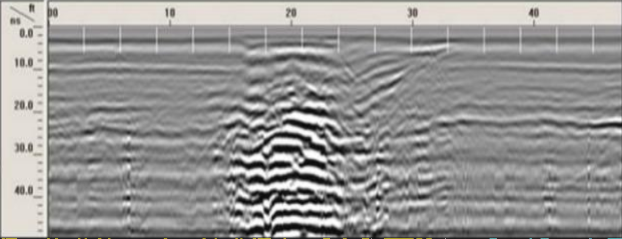
Image 3: Ground-Penetrating Radar data as displayed by a graphic recorder
Stormwater System Retrofitting
The growth of the urban area in the cities, constitutes one of the most important themes in the territorial ordering. This process has negative effects on the water cycle, in addition to urban floods. Stormwater management techniques, such as, retrofits include new installations or upgrades to existing Best Management Practices (BMPs) in developed areas.
Retrofitting existing storm sewer system could provide increase in system resilience, flood risk reduction, increase in pervious areas, reduction of flow volume, among others.
In many situations decisions are made based on predetermined factors, such as the reduction of pollutants, BMP feasibility and performance [10].
Often retrofits is an option for existing storm urban systems. Several examples are:
- Retrofit existing older stormwater management facilities (detention ponds)
- Construct new stormwater system at storm drainage pipe outfalls (end of pipe)
- Construct new stormwater system at upstream end of road culverts
- Construct small instream in open channels
- Construct “on-site” measures at the edges of large parking areas
- Construct new stormwater system within highway rights-of-way (cloverleaves) [11]
- Implement Low-Impact Development measures within existing systems
These and other retrofitting techniques will be taken into account to reach the objectives of this work.
References
-
Junta de Planificación de Puerto Rico y Departamento de Recursos Naturales y Ambientales de
Puerto Rico, Guías para la Elaboración de Estudios Hidrológicos-Hidráulicos, Junio, 2016.
-
Bonnin, G. M., D. Martin, B. Lin, T. Parzybok, M. Yekta, and D. Riley, 2006. “Precipitation
Frequency Atlas of the United States” NOAA Atlas 14, Volume 3, Version 4.0, NOAA, National Weather Service, Silver Spring, Maryland.
-
US Weather Bureau, 1961. “Generalized Estimates of Probable Maximum Precipitation and Rainfall-n
Frequency Data for Puerto Rico and Virgin Islands”, Technical Paper No. 42 (TP-42), US Department of Commerce, Washington, DC.
-
Hayhoe, K., Quantifying Key Drivers of Climate Variability and Change for Puerto Rico and the
Caribbean, Final Report, 2013.
-
Ahmed, S. and Tsanis, I., Climate Change Impact on Design Storm and Performance of Urban
Storm-Water Management System – A Case Study on West Central Mountain Drainage Area in Canada, Hydrology Current Research, Vol7, Issue 1, 2016.
-
Giusti, Ennio V., 1978, Hydrogeology of the Karst of Puerto Rico, Geological Survey Professional
Paper, U.S. Geological Survey, 1012, 78 p.
-
Barr, G.L., 1993. Application of Ground-Penetrating Radar Methods in Determining Hydrogeologic
Conditions in a Karst Area, West-Central Florida, U.S. GEOLOGICAL SURVEY, Water-Resources Investigations Report 92-4141.
-
Collins,M.E., M.Cum and Hanninen, 1994. Using ground-penetrating radar to investigate a.
subsurface karst landscape in north-central Florida, Geoderma,V.61, No. 1–2, p. 1-15.
-
Lyskowski, M., E. Mazurek and J. Zietek, 2014. Ground Penetrating Radar Investigation of
Limestone Karst at the Odstrzelona Cave in Kowala, Swietokrzyskie Mountains, Poland, Journal of Cave and Karst Studies, V. 76, no. 3, p. 184–190.
-
USEPA, 2011, Stormwater Retrofit Techniques for Restoring Urban Drainages in Massachusetts
and New Hampshire, Small MS4 Permit Technical Support Document, https://www3.epa.gov/region1/npdes/stormwater/assets/pdfs/BMPRetrofit.pdf.
-
Stormwater Retrofits: Tools for Watershed Enhancement, Technical Note #48 from Watershed
Protection Techniques. 1(4): 188-191.
|
|